Apparently, this place is Ötschergräben (+47° 50' 33.57", +15° 14' 14.76").
Showing posts with label Adrenaline. Show all posts
Showing posts with label Adrenaline. Show all posts


Canyon Zip Lining at Chutes Coulonge
Harness: Check.
Helmet: Check.
Empty Bowel: Check.
Time to head to the Colounge Canyon where you'll find the 250 meter (820 ft.) zip line. There's no time to think, let alone turn around. It's time to get down to business. Hang on tight and jump.

Wow, that was fun! Time to cross a cable footbridge back to this side of the canyon for the next part of our adventurous journey. The via ferrata (Italian for "road of iron) is quite literally an iron trail along the prehistoric rock face of the canyon.

The Via Ferrata runs 500 metres up the gorge towards the waterfall

but not before another short zip line.

You walk around the corner to find a 46 meter cable tightrope over the chasm. Oh yeah!

And then it's time to ascend the steepest and sheerest section of rock wall

where you get a spectacular view of the waterfall


The Via Ferrata runs 500 metres up the gorge towards the waterfall

but not before another short zip line.

You walk around the corner to find a 46 meter cable tightrope over the chasm. Oh yeah!

And then it's time to ascend the steepest and sheerest section of rock wall

where you get a spectacular view of the waterfall

But there's still one more zip line to tackle and this time you get a running start! This one crosses high above the canyon and is 100 meters long by 35 meters high. Simply amazing!
Ziplining and via ferrata'ing at Chutes Colounge was a lot of fun and I didn't soil my pants!
The Grizzly Bears of Banff National Park
Where there's...

there must be a grizzly bear and her two cubs nearby....


I watched these guys for 45 minutes before they stumbled their way into the forest.
I came back the next day to the same area in hopes of seeing them again, and surprise, surprise, I did, or at least some of their friends, including this bear...
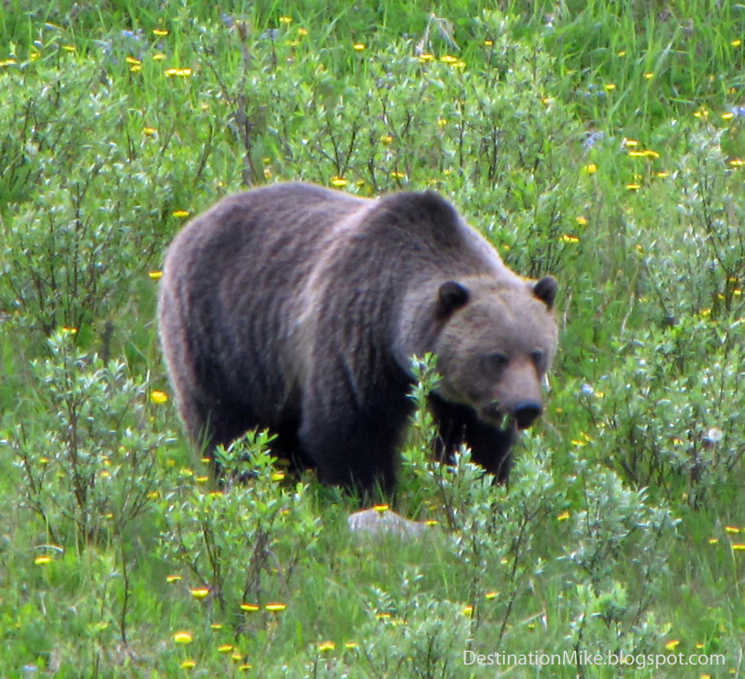


who was just going about its business, munching away on grass and dandelions, until another grizzly came out of the forest into the meadow. They stared each other down for a moment and then the chase began. Here's a quick video of the very end of it....
Lake O'Hara: A Hiker's Paradise
Words can not describe Lake O'Hara but perhaps Kathy & Craig Copeland, the authors of Don't Waste Your Time in the Canadian Rockies, describe it best:
To protect this sensitive alpine area and maintain a wilderness experience, Parks Canada has a quota system in place to limit the number of visitors using the public bus service into Lake O'Hara. The daily quota allows 42 day users, along with overnight visitors staying at the park's 30-site campground, two Alpine Club of Canada huts, and a small, private lodge.
As soon I found this out, I was on the phone trying to reserve a spot of the shuttle bus. An hour and a half later, I finally got through. And yes, they had one last spot on the bus for me! Lucky me as Parks Canada recommends booking three months in advance.. Doesn't that sound familiar...
Of course, you can walk (but not bike) the 11km restricted access road to the Lake but who really wants to do that boring trek?
Despite the fact that it was late June, it was a late spring, and the trail reports didn't paint a rosy picture: deep snow, avalanche warnings, closed trails. But who knows when I will have another chance of doing this so off I went.
After everyone boarded the first bus of the morning, the Parks Canada employee welcomed everyone on board and warned off the trail conditions and limited hiking opportunities around the Lake and to Lake Oesa. Upon hearing about the deep snow conditions, one of the flip-flop wearing tourists raised their hand and asked, "Umm, when's the first bus scheduled to come back?" Sweet! Yes, I'll admit it. I was selfish. I cherished the thought of even fewer people hanging around the lake that day. If you're not prepared for the weather and trail conditions, you might as well go back home folks!
After the twenty-five minute bumpy bus ride up the access road, it was time to get out and take in this natural wonder. Out of curiosity, I first popped into the Lake O'Hara Trail Club Day Shelter for a quick look. There was a drum full of walking sticks you can borrow. Having never used a man-made walking stick, I borrowed one for the day. While I still have some doubts about their claimed practicality, I'm sure glad I used one that day. I'm still not 100% convinced that they are as good as all the marketing hype suggests but I digress...
It was time to head out on the trail. Before even hitting the lake, it started to drizzle but it wasn't anything too dramatic. I must admit that my first impression wasn't too favourable as there was this rumbling sound coming from across the lake. After traveling all this way, are we really that close to another highway?
But no need to fear. As I walked a little farther along the lakeshore, I soon realized those sounds were not from a neighbouring highway but a series of waterfalls at the far end of the lake. That I can appreciate.

According to the trail report, the Lake O'Hara Trail was the only trail in relatively fair spring-time condition with some snow patches so it was the first trail of the day. It's a pleasant and easy loop around the lake that provides commanding views of the mountains around the lake but this is not what Lake O'Hara is renowned for.
Rather it is the Lake O'Hara Alpine Circuit that makes serious hikers grin from ear to ear. According to Kathy & Craig Copeland,

On the way down, I came across my first hoary marmot. As I went for my camera, the shy marmot quickly ran into the trees.

I walked in a bit closer and I saw what could be a little snow covered pathway along the cliff. Yes, I found it. Thank you Mr. Marmot!

Yes, that is the trail! As I continued past some interesting ledges, rock slides, avalanche paths, and streams, I soon lost the trail again. Oh well, at least, I can enjoy the scenery.
Retracing my steps, a ground squirrel pops up nearby so I take a photo and rediscover the path a bit upstream. Thank you Mr. Squirrel!


So once again, I'm hiking along the official trail, and now the small yellow and blue painted trail markers are becoming a little more frequent along the ledges and switchbacks but then I'm off the trail again, and this time, I think there's nowhere else to go.
Time to turn back but then, and I'm not making this up, I notice yet another ground squirrel pop up right next to what appears to be the continuation of the trail, and sure enough it is. Thanks again Mr. Squirrel! (or is it Mrs. Squirrel and Mrs. Marmot?).

The path starts going up even further. That's bad news because there's only snow up there. Looking at the trail map, it doesn't look promising. It looks as though the trail for the foreseeable distance is covered in deep snow. Darren lent me his microspikes for extra traction on any icy ledges I might came across but they'd be of little use in deep snow. Plus I was alone. I didn't pass anyone on the trail, and there's no path to follow in the snow. Time to head back and tackle the Gap another time.
From up here, the trail to Lake Oesa looks interesting. Time to check it out.
"Magic mushrooms. Cannabis. Tequila. Lake O'Hara.After reading a description like this, it's hard not to put on the hiking boots right here and now!
All will get you high.
All are controlled substances.
The difference: limitations on
Lake O'Hara
protect it,
not you."
To protect this sensitive alpine area and maintain a wilderness experience, Parks Canada has a quota system in place to limit the number of visitors using the public bus service into Lake O'Hara. The daily quota allows 42 day users, along with overnight visitors staying at the park's 30-site campground, two Alpine Club of Canada huts, and a small, private lodge.
As soon I found this out, I was on the phone trying to reserve a spot of the shuttle bus. An hour and a half later, I finally got through. And yes, they had one last spot on the bus for me! Lucky me as Parks Canada recommends booking three months in advance.. Doesn't that sound familiar...
Of course, you can walk (but not bike) the 11km restricted access road to the Lake but who really wants to do that boring trek?
Despite the fact that it was late June, it was a late spring, and the trail reports didn't paint a rosy picture: deep snow, avalanche warnings, closed trails. But who knows when I will have another chance of doing this so off I went.
After everyone boarded the first bus of the morning, the Parks Canada employee welcomed everyone on board and warned off the trail conditions and limited hiking opportunities around the Lake and to Lake Oesa. Upon hearing about the deep snow conditions, one of the flip-flop wearing tourists raised their hand and asked, "Umm, when's the first bus scheduled to come back?" Sweet! Yes, I'll admit it. I was selfish. I cherished the thought of even fewer people hanging around the lake that day. If you're not prepared for the weather and trail conditions, you might as well go back home folks!
After the twenty-five minute bumpy bus ride up the access road, it was time to get out and take in this natural wonder. Out of curiosity, I first popped into the Lake O'Hara Trail Club Day Shelter for a quick look. There was a drum full of walking sticks you can borrow. Having never used a man-made walking stick, I borrowed one for the day. While I still have some doubts about their claimed practicality, I'm sure glad I used one that day. I'm still not 100% convinced that they are as good as all the marketing hype suggests but I digress...
It was time to head out on the trail. Before even hitting the lake, it started to drizzle but it wasn't anything too dramatic. I must admit that my first impression wasn't too favourable as there was this rumbling sound coming from across the lake. After traveling all this way, are we really that close to another highway?
But no need to fear. As I walked a little farther along the lakeshore, I soon realized those sounds were not from a neighbouring highway but a series of waterfalls at the far end of the lake. That I can appreciate.

According to the trail report, the Lake O'Hara Trail was the only trail in relatively fair spring-time condition with some snow patches so it was the first trail of the day. It's a pleasant and easy loop around the lake that provides commanding views of the mountains around the lake but this is not what Lake O'Hara is renowned for.
Rather it is the Lake O'Hara Alpine Circuit that makes serious hikers grin from ear to ear. According to Kathy & Craig Copeland,
"Actually it's not a trail. It's a route.
An acrophobe's nightmare.
Catwalks, ledges and paths linked to create a loop.
Mostly above treeline.
Often clinging to the walls of skyscraping mountains."
So no more waiting around. The drizzle had stopped. According to the trail reports, the Circuit was still snow covered and the Parks Canada official warned of very deep snow up to Wiwaxy Gap. Nevertheless, I had to at least give it a shot. The Wiwaxy Gap Trail starts with a steep climb up a narrow trail. There still were snow sections on the trail, which made the climb a bit more treacherous but not as difficult as the rock scree higher up. At least snow compresses to provide decent footing. As I continued climbing up, I started thinking that this is ridiculous. Here I am, all alone, going up this side of the mountain in a canyon filled with loose rock with no clear path, on a trail that was unofficially closed with no evidence that anyone walked this way this year. What if something happens to me? Who's going to help me? No one knows I'm up here. My cell phone has no reception. As I continued my way slowly up, I thought to myself that this can't possibly be the trail and seeing how it seems to look like this all the way up the mountain, I decided to turn back.

On the way down, I came across my first hoary marmot. As I went for my camera, the shy marmot quickly ran into the trees.

I walked in a bit closer and I saw what could be a little snow covered pathway along the cliff. Yes, I found it. Thank you Mr. Marmot!

Yes, that is the trail! As I continued past some interesting ledges, rock slides, avalanche paths, and streams, I soon lost the trail again. Oh well, at least, I can enjoy the scenery.
Retracing my steps, a ground squirrel pops up nearby so I take a photo and rediscover the path a bit upstream. Thank you Mr. Squirrel!


So once again, I'm hiking along the official trail, and now the small yellow and blue painted trail markers are becoming a little more frequent along the ledges and switchbacks but then I'm off the trail again, and this time, I think there's nowhere else to go.
Time to turn back but then, and I'm not making this up, I notice yet another ground squirrel pop up right next to what appears to be the continuation of the trail, and sure enough it is. Thanks again Mr. Squirrel! (or is it Mrs. Squirrel and Mrs. Marmot?).

The path starts going up even further. That's bad news because there's only snow up there. Looking at the trail map, it doesn't look promising. It looks as though the trail for the foreseeable distance is covered in deep snow. Darren lent me his microspikes for extra traction on any icy ledges I might came across but they'd be of little use in deep snow. Plus I was alone. I didn't pass anyone on the trail, and there's no path to follow in the snow. Time to head back and tackle the Gap another time.
From up here, the trail to Lake Oesa looks interesting. Time to check it out.
Black Bears vs. Dandelions
Do you have a dandelion problem in your backyard?
Don't despair, there's a simple, eco-friendly solution to this common weed problem.
Simply get yourself a black bear and say goodbye to those stubborn dandelions.

Of course, I am a bit facetious but all six of the black bears I saw in Banff National Park were chomping away on dandelions like there was no tomorrow.


They could have cared less about their surroundings as long as dandelions were around.
Hailstorm at Johnston Canyon
Johnston Canyon is a very popular trail in Banff National Park but despite the crowds, it was the first major trail I came across on the Bow Valley Parkway, and considering there were a few spots left in the parking lot, I thought that this might be my one chance to give this trail a shot with a bit of tranquility.
The popularity of this trail can be attributed to its relative proximity to the town of Banff, its unique setting, and its accessibility. There are not many places where you stroll along a paved walkway over a torrent making its way between sheer cliffs.

Despite signs asking people to do the contrary, it's very evident that a lot of people give in to the begging chipmunks and feed them an assortment of treats. Some of the chipmunks along the trail were fat, and when I say fat, I mean fat! Maybe 2.5x as wide as your regular chipmunk!
This is definitely not a backcountry trail. The trail begins as a paved walkway for the first 1.1 km to the Lower Falls, where Johnston Creek plunges 10 metres into a pothole below.

If you're curious, you can huddle down and walk through a short tunnel to get a closer and wetter look at the falls. It's a great way to cool off on a hot day!

After viewing the falls from above and below, you have the option to turn around or continue to the Ink Pots. Now most of the time, I'd be tempted to hike the extra 3 km but the trail books warned of potential disappointment so I decided against it this time around, and instead started heading back while taking in the sights and sounds. The sky was clear, the temperature was just right, and the trail wasn't too crowded. Ahhh, a perfect day in the park. But as I hit the Lower Falls, it started to cloud over and the wind picked up. Next thing you know, it's raining and things aren't that pleasant any more. Time to hurry on back to the car but then there's thunder and lightning and I'm on a steel and concrete walkway over a mountain stream. And the wind is starting to pick up even more. Hey grandmas, no more nice and polite Mike! Time to get out of the way! Mike's not ready to die just yet! I finally reach the end of the walkway, just to see trees crashing in front of me! And here comes the hail! Oh my, time to just gun it!
Luckily, I didn't check out the Ink Pots and made it to the car safely, where I watched trees swaying out of control. Those trees were a little too close for comfort so despite the heavy rain and hail, it was time to head onto the Parkway where it was perhaps a little safer but then again, I had to drive around several fallen trees on the road before reaching Lake Louise, where the power was out, along with the rest of the surrounding area including Banff and Golden.
They say that the weather can change in a whim in the mountains, and just witnessed it!
Spring Carnage on the Ottawa River

They say spring is the best time to go whitewater rafting on the Ottawa River... and the Spring of 2011 is promising not to disappoint.
Combine the Class I - IV rapids with the snow melt and the record rainfalls this spring, and we're slated for an epic rafting adventure as we jumped into our raft towards the world famous Rocher Fendu rapids of the Ottawa River.
If you don't already know, I hate getting wet. And let's not talk about my thoughts on head dunking. So it shouldn't come as a surprise that my swimming skills aren't the greatest.
Yet here I am, up for the challenge!
No better way to learn how to swim than to be exposed to a potentially life threatening situation, right?
First, a look of a map of the rapids on this section of the Ottawa River...

First, a look of a map of the rapids on this section of the Ottawa River...

As we approach the first rapids of the day, McCoys Chute, our guide tells us this is just a warm-up for things to come... Tell that to the huge wall of water crashing into my mouth!
Get ready to swim! What? Not if I can help it! Well, I guess I couldn't help it because one second, I'm paddling away, and the next, bamm, crashing waves of water hitting me, and the next thing I know, all I see is dark brown water....Which way is up? Shouldn't it be getting brighter??? Time to flip around.... How long have I been under? It feels like an eternity.... So this is how my life story ends... Ahh, I see light! It's getting a little brighter! Thank you PFD! Hmmm, where's my raft? Which way did they say to swim? Which way is right? Or was it left? Oh, I see a couple of people floating nearby? More rapids approaching! Oh boy! Oh wait, a raft is approaching. They look friendly.. why can't I get closer??? I'm trying to swim but I'm not moving! The other floaters are closing in on the raft... why aren't I? Hello new friend, yes, I would like to grab your T-handle. Thanks buddy. You just saved my life! Back on board but more rapids are quickly approaching. The paddle's back in the water. Time to get back to work... but the guide shouts out, "Hey you, up front, stop paddling and just hang on tight!"
Oh, what a day! There is so much more I can talk about like the other rapids, people, food, and facilities but I'll leave that up to you to discover on your own when you head out for a rafting trip on the dynamic Ottawa River. Thanks RiverRun Rafting for making my first whitewater experience one I won't forget anytime soon.

Snow Biking
Mountain Biking Death Road
June 5, 2010 (Day 18)
After a few days of tranquil relaxation, it was time to step it up a notch, and mountain bike down “The World's Most Dangerous Road."
Yes, that's right, the World's Most Dangerous Road, as dubbed by the Inter-American Development Bank in 1995, and locally known as "Death Road" or "Camino de la Muerte!"
So why is it called that? Well, according to Wikipedia, the North Yungas Road is legendary for its extreme danger and an estimated 200 to 300 travellers were killed yearly along the road, and at least 18 cyclists have died on the ride since 1998.
After confidently signing up the previous evening at the Gravity Assisted Mountain Biking office in downtown La Paz (despite the employee's arm being in a cast!), Steph and I headed to Alexander's Coffee for breakfast to join up with our fellow thrill seekers. At 7:30, we hopped into the van and started our 1-hour drive to La Cumbre.

After getting decked out in the helmet and outerwear provided, we prepped our bikes, and solemnly swore that we would not be idiots today and saluted Pacha Mama with a sip of a vile alcoholic beverage that we then sprinkled on our bike tires and the ground.
After a few days of tranquil relaxation, it was time to step it up a notch, and mountain bike down “The World's Most Dangerous Road."
Yes, that's right, the World's Most Dangerous Road, as dubbed by the Inter-American Development Bank in 1995, and locally known as "Death Road" or "Camino de la Muerte!"
So why is it called that? Well, according to Wikipedia, the North Yungas Road is legendary for its extreme danger and an estimated 200 to 300 travellers were killed yearly along the road, and at least 18 cyclists have died on the ride since 1998.
After confidently signing up the previous evening at the Gravity Assisted Mountain Biking office in downtown La Paz (despite the employee's arm being in a cast!), Steph and I headed to Alexander's Coffee for breakfast to join up with our fellow thrill seekers. At 7:30, we hopped into the van and started our 1-hour drive to La Cumbre.
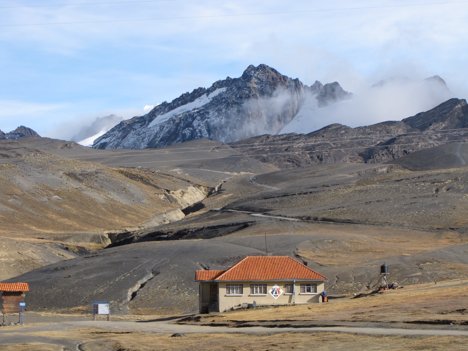
After getting decked out in the helmet and outerwear provided, we prepped our bikes, and solemnly swore that we would not be idiots today and saluted Pacha Mama with a sip of a vile alcoholic beverage that we then sprinkled on our bike tires and the ground.

And so it begins… the bike ride of our lives, down more than 3,600 metres, from high-altitude plains and mountain ranges down to the steaming Amazonian jungle!
We began the ride at La Cumbre (4,700m) where we had great views of a number of snow-covered peaks. From here, we descended rapidly down a twisting asphalted road (known affectionately as "The Tarmac") right next to less-than-sympathetic trucks and buses, among mountain peaks, tiny villages and of all things, a drug check-post.

This was deemed to be the easy part of the trek, yet I'd argue that it might be just as dangerous as the rest of the ride. Since the road was asphalted, you pick up speed very quickly and one tiny slip on one the many tight curves, and you'd be scrapping yourself across the road into an upcoming vehicle or down a cliff! And to top it off, as you're heading down, you suddenly hit the clouds, resulting in almost zero visibility in front of you. Now the clouds were expected to clear up as we headed down in altitude but they really didn't as it turned a bit misty as we hit the jungle, which isn't the greatest thing as you can imagine for someone like me wearing glasses! So at every stop, I'd be trying to clean off my glasses so I could actually see the road ahead of me! Yes, the nerd tried to be hardcore adventurous today, and the nerdiness really showed ;)
Then came the part our guide unapologetically said the office intentionally avoided to mention: an 8-km uphill section. It's not like it was a ridiculous uphill section at sea level, but we weren't at sea level, but several kilometres above it, and I was still trying to get over my sniffles! The uphill ride began and so did the showers but after stopping a few times to catch my breath and wipe my glasses, slowly but surely, we were back to heading downhill.
We were now officially on Death Road and you can definitely see why it would be called that as the narrow dirt road is cut into the side of a mountain with barely enough room for a single car, let alone opposing traffic.

With 1,000+ metre sheer drops off to our left and massive rock overhangs and cascading waterfalls to our right, and the occasional car coming around a blind corner, we hurtled down this winding road, passing many crosses and memorials along the way to remind us of the dangers just a few feet away.

As we neared the last quarter of the ride, the mist disappeared and we started shedding off layers of clothing as it got progressively hotter.
By the time we arrived at the bottom in Yolosa (1,100m), we were all hot, muddy, and ready for a shower so we rode down to La Senda Verde Animal Refuge to enjoy our well-deserved beer, shower, and buffet lunch. The Animal Refuge is run by volunteers from all around the world, who take care of rescued tropical animals ranging from macaws to monkeys to caimans and pretty much everything in between. This was a very nice place to catch a closer look at the local wildlife, while ensuring the monkeys don't steal your belongings, and we could have easily spent the night there at one of their cabins or treehouses. But we didn't have a reservation, so after a few hours, we got into the van, and headed back up Death Road, this time in the car, and got another look of our journey earlier in the day.
The fog cleared up and since we were heading up the Road very slowly, we had a chance to truly appreciate how steep and deep those cliffs and canyons were! What were we thinking!?!
Combine this with the cars we had to pass along the way, both on our bikes and in the car, and we had the full Death Road experience! Well, everything but the express trip over the edge! And that's a good thing!
Video sampling Death Road's reputation is courtesy of luks01guitar
Now for a quick review of Gravity Assisted Mountain Biking's "The World's Most Dangerous Road" Tour:
While there are cheaper alternatives, I chose Gravity Assisted Mountain Biking (GAMB) for their good safety reputation, English-speaking guides, and the end-of-day extra of a visit to the Animal Refuge. Other tour operators are probably a lot cheaper but do you really want to go with the cheap option when all that's separating you and death are a couple of small bike brakes? Well, I didn't and it was comforting to have two radio-bearing, English-speaking guides (one of which was American) explaining the road ahead and any special precautions we had to take.
As for the bikes, they were Kona's. Of course, nothing would beat having your own bike for such expeditions but when you have to settle for a supplied one, you can't really complain too much about a Kona. That said, my pedal crank completely jammed on several frustrating occasions when I really needed to pedal, either up a hill or upon exiting a stream, and was quickly losing any usability as we approached the Sanctuary so I wasn't completely sold on GAMB's supposed impeccable maintenance standards but then again, it could have just been something small getting stuck in the chain as it seemed to start skipping a chain segment when pedaling at some point of the trip, and that feeling wasn't present at the beginning of the day. According to one of the guides, the other tour companies buy GAMB's bikes once they're deemed unacceptable for riding. I’m not quite sure what that means exactly considering you can almost always repair a bike but anyways, I didn't see the other companies' bikes so I can't make an honest judgement for myself.
I will also note that the whistles the guides said they'd blow to warn us of vehicles weren't heard by us.
One of the guides was responsible for taking photos of our journey, and while some were good, they could have been better but then again, his primary job was to make sure we rode down the mountain road safely so you can't really blame him but it would have been nice if more photos were taken. A photo CD was available for purchase after the trip but a shirt and balaclava were included in the tour price.
Now I can say, "Death Road: Been there. Done That. And I've got the t-shirt to prove it!"
All in all, it was an unforgettable experience and considering it was unforgettable for all the right reasons, I’d definitely do it again along with some of GAMB’s other rides.
Now for a few quick tips regarding the trip:
- You don't have to be an expert cyclist to bike this road as there's nothing very technical about the ride. In fact, being overconfident is probably the biggest threat. Just keep your eyes on where you want to go and if you're feeling uncomfortable, just try to take it nice and slow. And in the case of the 8-km uphill portion, you have the option of boarding the van for that portion, or for any other portion, for that matter.
- Make sure you go to the right Alexander's Coffee pick-up location, unlike our American counterparts, who ended up at the wrong location and needed to take an expensive taxi ride up to La Cumbre to catch up to us and avoid losing out on this experience and their money.
- If you need to wear prescription eyeglasses and can stand wearing contacts, do so! If you can't, be sure to carry several handkerchiefs to help clean and dry your glasses along the ride.
- A baseball cap under my helmet helped keep some of the showers and waterfalls away from my glasses.
- Bring a small camera that you can easily pull out of your pocket. We left our cameras in the van because they were too big to lug around on our necks while hurling down the mountain so we ended up not taking many of our own photos and relied almost solely on the guide’s photographic ambitions.
- Be sure to bring the 25 Bolivianos (in exact change) that you'll have to pay for the tourist biking toll at Unduavi, along with some extra cash for additional beverage purchases and to make a donation at the La Senda Verde Animal Refuge, if you are so inclined.
- Wear layers. It's cold and windy up top and hot and humid at the bottom. And don't wear anything too nice. Even with the seemingly water-resistant pants they provided, the pants I wore underneath still somehow, inexplicably, ended up being muddy too, and I assure you that I did not soil them!
- Bring a spare set of clothing to change into for your journey back.
- Be sure you and everyone entering the shower lodge, closes the front door immediately, or you might have a monkey come in and take a shower with you!
- And last but not least, some important advice from our guides "When cycling down Death Road, Remember: Don't look at the pretty birds and butterflies, their job is to f'ing kill you!" LOL
Machu Picchu
May 31 (Day 13)
Boom, boom, boom! There's a party in my room!
Unfortuantely, there isn't.
It's just before midnight and we wake up to what sounds like a marching band right next door. But it's the middle of the night. It must be some idiot downstairs blaring his stereo. I get up and look out the window and sure enough, it's a bloody parade complete with a marching band and dancing women! I must be dreaming. I pinch myself, rub my eyes, look out the window again, and still see a parade circling the main plaza square just feet away from our hostel!
Unfortuantely, there isn't.
It's just before midnight and we wake up to what sounds like a marching band right next door. But it's the middle of the night. It must be some idiot downstairs blaring his stereo. I get up and look out the window and sure enough, it's a bloody parade complete with a marching band and dancing women! I must be dreaming. I pinch myself, rub my eyes, look out the window again, and still see a parade circling the main plaza square just feet away from our hostel!
Don't these people know that the only reason people stay overnight in Aguas Calientes is to wake up extra early the next morning to catch the sunrise atop Machu Picchu? Welcome to Aguas Calientes, where they parade day and night.
Back to bed as we're waking up at 4am to get in line for the bus to Machu Picchu. Yes, that's right. 4am! We talked to quite a few people the day before, and there was consensus that if you wanted to catch one of the first set of buses to Machu Picchu, you'd have to get in line by 4:30am to have a chance.
We purchased our bus tickets the day earlier at the kiosk, and good thing we did, because I don't think the wicket was open that early in the morning. If you're budgeting for your trip, here are the bus ticket prices to get you to the Machu Picchu Sanctuary entrance from Aguas Calientes (Machu Picchu Village).

So we waited in line until around 5:30am when they started loading up the buses, and it was then up the winding road to Machu Picchu.
Considering we didn't have a chance to hike the Inca Trail, I really wanted to climb Huayna Picchu (Wayna Picchu), which is the mountain rising over Machu Picchu.

In none of the literature I read about Machu Picchu was it clear where we could pick up tickets to climb Huayna Picchu. All I knew was that they were available somewhere at the Sanctuary. It ended up not being an issue as we just lined up like everyone else at the Sanctuary's entrance and two officials just walked down the line and asked if we wanted to be part of the 7am or 10am group. There apparently is a larger demand for the seven o'clock admission but since we had the choice of either time slot, we chose the ten o'clock slot as there would be fewer tourists at Machu Picchu in the four hours leading up to 10am, than after returning from the summit. The number of daily visitors allowed to enter Huayna Picchu is restricted to 400 so we considered ourselves lucky (and smart) to have received these coveted tickets without any difficulties besides having to wake up extra early.
After the gates to Machu Picchu opened at 6:00 am, we walked up the pathway and were greeted to the following spectacular view...
The moment had finally come.. we actually made it to Machu Picchu! The sun was shining and it was neither too hot or too cold. Just perfect! You can read about the history of Machu Picchu elsewhere so I'll just post some photos for your viewing pleasure...


And the Inca Bridge...

Ten o'clock was quickly approaching so it was time to head to the gateway to Huayna Picchu, and make our way up the steep stairs hugging the edge of the mountain. Climbing the mountain was a test of determination and endurance as the altitude was showing its effects on people we passed on our way up. This trail is definitely one you don't want to rush as the scenery is simply spectacular and the limited number of hand railings (in the form of steel cables bolted to the bedrock) makes climbing the narrow and steep stairs a bit dangerous as one wrong step or slip could result in a nasty fall. Irregardless, the hike was definitely worth it and was undeniably, the highlight of the day as the hike and view of Machu Picchu and the surrounding mountains, canyons, and river below provided a surreal and an unforgettable experience.
The climb down the mountain was actually more difficult than the climb up as the steps are not only steep but also very small. They were barely the width of my foot so I had to walk sideways down a majority of the steps on the upper portion of the mountain or else I would have certainly fallen.

Now for some tips regarding your visit of Machu Picchu:
- Bring a small daypack to carry your water bottle, snacks, camera, batteries, sun block, shorts, and extra t-shirt.
- Wear hiking shoes with good threads if you plan on hiking Huayna Picchu.
- A guide isn't necessary. Stick around a spot long enough, and you'll hear guides talk about it in several different languages. The funny thing is that the guides sometimes contradict one another in their explanations.
- Get there early. The tour groups arrive later in the day and they are pretty big.
- Don't be afraid to ask the Sanctuary's employees for assistance in taking photos or getting directions. They're really friendly and helpful..
- Don't be in a rush. You've come a long way to see this. Enjoy your surroundings!
So to conclude, there's a lot of hype surrounding Machu Picchu but based on my experiences, it's definitely warranted. A trip to Peru would not be complete without a visit to this amazing archeological discovery.
Subscribe to:
Posts (Atom)
Popular Posts
-
 In the last post , we had a glimpse of VIA Rail's Economy Class offering on The Canadian . So is it worth paying extra for VIA's S...
 -
 Upon boarding the train, I was informally offered an upgrade to a private cabin by a VIA Rail crew member. Of course I'll take it! Afte...
 -
 Travelling in economy class on VIA Rail's The Canadian train provides you access to the Economy Car and Skyline Car. Here are some pics...
 -
 Christmas is a festive time of year and in keeping with the spirit of the season, many of the windows in Downtown Victoria turn into magical...
 -
 One of the perks of travelling in the Sleeper Plus Class on VIA Rail's The Canadian train is the food. Delicious meals are prepared on...
 -
 When travelling in the Sleeper Plus Class of VIA Rail's The Canadian , not only do you have access to the Economy Class ' panoramic...
 -
 May 30 (Day 12) The day begins with an early taxi ride to the train station. There were some concerns earlier in the week when we came ...
 -
 Words can not describe Lake O'Hara but perhaps Kathy & Craig Copeland, the authors of Don't Waste Your Time in the Canadian Rock...
 -
 After grabbing a bite to eat at the Plain of Six Glaciers Tea House , it was time to get back to business and start the hike up to Lake Agn...

